Cemeteries – Remote Plaques NT
What are these?
Nine cemeteries have bronze plaques installed, Adelaide River, Brock’s Creek (Zapopan), Port Darwin Camp, Stapleton, Emungalan, Southport, Rum Jungle, Maranboy and Fort Dundas.
In researching rural cemeteries our Society put forward to the Heritage Branch of the Northern Territory Government, a proposal to install bronze markers in our early rural cemeteries. These cemeteries are no longer in use but they remain a significan part of our history – they are the resting place of pioneers who helped make the Territory what it became.
The Heritage Branch of the Northern Territory Government is working towards having these cemeteries signposted and incorporated into a heritage trail for locals and tourists.
Each marker states the names of the deceased and the date of death. It is a fitting mark of respect to our Pioneer Territorians.
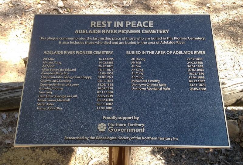
ADELAIDE RIVER PIONEER CEMETERY
Lot No. 100 Adelaide River NT Heritage Register signed by Minister 10 October 1996, Gazetted 30 October 1996 Geographical Co-ordinates 13 15 131 06
Adelaide River was discovered in 1839 by a Mr Fitmaurice who was on board the survey ship the Beagle. Mr Fitmaurice was on a boating expedition from the Beagle when he came across a river which he named in the memory of Queen Adelaide, wife of William IV, Duke of Clarence.
In 1873 the first person to cater for the travelling public was George Thomas Dogherty who built a roughly constructed building of logs covered in bark, he opened a restaurant. A little later Mr H. S. Finlay built an improved building and opened the first hotel at the River, he named it the “Q.C.E. Hotel” (Quiet, Comfort & Ease). The Hotel operated until March 1874 when it was sold to Mr E.P. Hopewell who later was the successful tenderer for the inland mails from Southport to Pine Creek.
In the pre war years Harvey Gribbon held a licence for the Adelaide River Railway Station Refreshment Rooms. After the war Jim Fawcett (Senior) held the licence until his retirement when Myrtle Fawcett took over the hotel. Five years after the war they moved to open up a Hotel on the present site under the mango trees left by Edwin Verburg in the late 1920’s and 1930’s.
The road from Southport to the Adelaide River was used by the telegraph line parties and was rough and uncertain in many places, Adelaide River was half way to the mining districts and was a favourite camping place for propectors and mining people.
The plaque in the cemetery lists those who were known to have been buried here, as well as those who died and were buried within the town boundaries.
Further burials have been discovered :-
Henry aka Harry Ewart drowned in the Adelaide River, an actual river location unknown, on 18 September 1918. It is presumed Henry was buried in this cemetery.
Kitty Ah Quee died on 03 February 1976
Fannie Allen died 20 December 1976
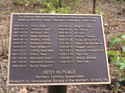
BROCK’S CREEK (ZAPOPAN)
South of Brock’s Creek Railway Station
Part of NT Por 2683 (Douglas) designated NT Por 5715(A) – Heritage Register Gazette G45 17 November 1999 Geographical Co-ordinates 13 27 131 28
Brock’s Creek takes its name from William Brock, a Government Assistant Inspector of Works of the Darwent/Dalwood team.
Six remaining gravesites situated on a flat area in open woodland covered by thick grass. Two wooden posts with some fencing wire attached remain at the northern and southern extremities of the remaining gravesites (approximately 56 paces apart) and at the western side of the area in which the remaining graves are located. It is likely that these are the remains of the fence erected around the cemetery in 1902.
A marble headstone in the shape of a cross resting on a concrete block marks George Alwynne Wilson’s grave. Iron railings set in concrete featuring ornamental ironwork on the corner posts surround the grave.
Clara Caddy’s grave is marked by the top half of a rusted tin memorial head plate and has iron fencing around the grave featuring a repeated fleur-de-lis pattern. Two seashells have been placed on the grave inside the fencing.
Another small grave is marked with a concrete border, one other is marked with a slate headstone and another with a border of rusted tin.
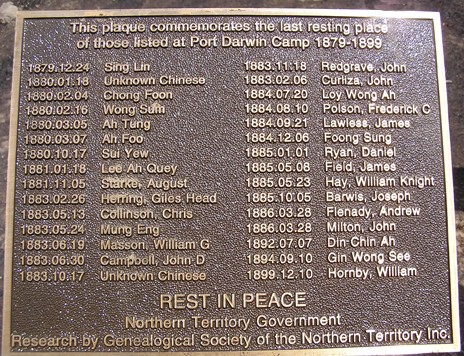
PORT DARWIN CAMP
Part of Douglas Pastoral Lease NT Por 2683 – south west of Grove Hill Hertiage Register NT Gov Gazette G20 15 May 2013 – Geographical Co-ordinates 13 31 131 32
Port Darwin Camp Mine was operating in this area in the 1874 to 1899 period.
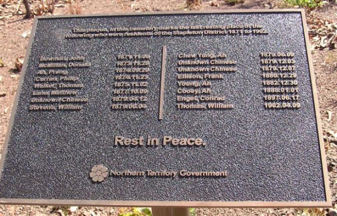
STAPLETON
Sect. Hundred of Waterhouse located in the vicinity of Stapleton Railway siding and Stapleton Lagoon Geographical Co-ordinates 13 10 131 03
Stapleton or Stapleton Creek was named by Surveyor G.R. McMinn after James L. Stapleton, a Senior Telegraph Operator at Barrow Creek in the Northern Territory, who was aged 41 years when he was speared at the Telegraph Station when it came under attack. Stapleton Creek was the site of the Our House Hotel operated by Edward Matthews from June 1874.
Bowman John 1871.11.06
McMillan Donald 1873.11.28
Ah Prung 1874.09.20
Curran Philip 1874.11.23
Walker Thomas 1875.11.02
Lane Matthew 1877.10.09
Unknown Chinese 1879.04.12
Stevens William 1879.06.04
Chew Yung Ah 1879.06.09
Unknown Chinese 1879.12.03
Unknown Chinese 1879.12.07
Ellison Frank 1880.12.29
Young Ah 1882.12.30
Cooey Ah 1888.01.01
Engel Conrad 1897.06.17
Thomas William 1902.04.09
EMUNGALAN
HAC2001/0348 Geographical Co-ordinates 14 27 132 14 – opposite side of the Stuart Highway near the Katherine Town Council building.
Emungalan was the Aboriginal name given to the old rail terminal on the northern bank of the Katherine River. It is believed to mean stony. It was later used as a suburban name in Katherine.
The Emungalan Cemetery is of heritage significance to the Territory as the resting-place for four people who died in or near the town of Emungalan between 1919 and 1924.
Between 1917 and 1926, Emungalan was an important district centre and the terminus for the Northern Territory Railway and, despite its short life, played a fundamental role in the development of the Territory. The cemetery is also of heritage significance as one of only two physical reminders of the existence of this temporary town.
The simplicity of the cemetery reflects the rudimentary nature of a frontier town, and is a reminder of the harsh and basic conditions that epitomised the lifestyle of many Territorians during the early days of the Territory’s development.
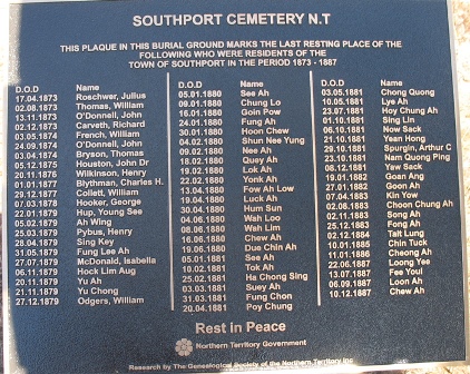
SOUTHPORT
Within Section 2231 Hundred of Cavenagh, Mira Road SouthportGeographical Co-ordinates 12 42 130 56
Surveyed by George Woodroofe Goyder in 1869 and settled soon afterwards.
Southport was an important district centre and port for the construction crews of the Overland Telegraph Line and prospectors travelling to the inland goldfields, and despite its short life, played a fundamental role in the development of the Territory.
Sixty six (66) people are recorded as being buried in the cemetery, mostly Chinese. Difficulties in living in a tropical climate in a remote location may be inferred from the numbers and causes of deaths and the variety of age, sex and former occupations of the deceased provide significant information in determining the population profile of Southport. The Southport Cemetery provides a tangible reminder of the exploits and lives of many who have contributed to the development of the Territory.
Each grave represents the last resting place of people whose contribution collectively is important to the interpretation of the Territory’s historical, social and cultural background.
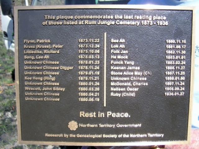
RUM JUNGLE
Rum Jungle Probably on Sect 2848 Hundred of Goyder, Bevan Road – cemetery opposite site of Hotel – Heritage consideration waiting comments from traditional owners – Geographical Co-ordinates13 00 130 57The name Rum Jungle has been used since 1873 with the reporting of the death of Patrick Flynn at Rum Jungle on 22 November 1873.
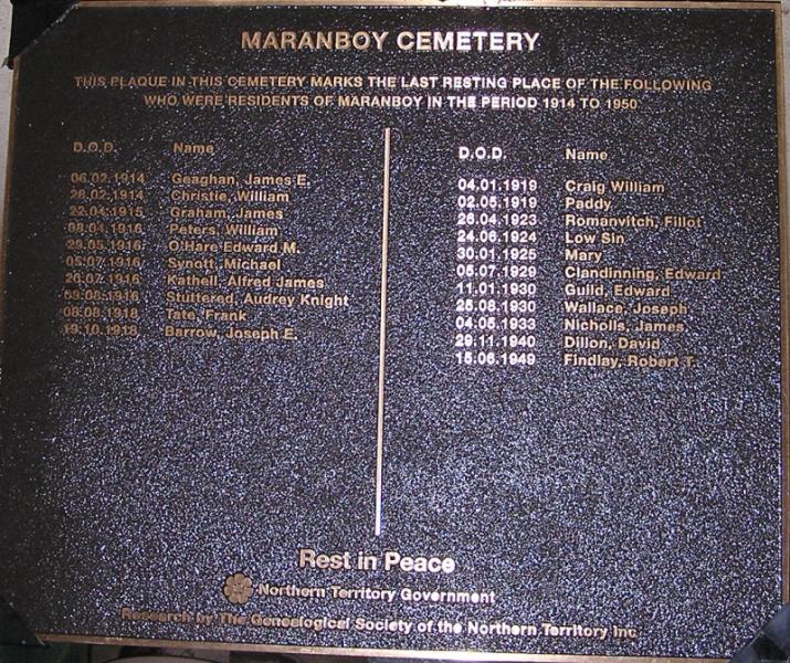
MARANBOY
Jawoyn Land Trust NT Por 3629 designated NT Por 6690 (A) – 1470 sq. metres more or less Geographical Co-ordinates 14 32 132 47
Maranboy Springs was first recorded in 1913 and is believed to be Aboriginal. The feature 40 miles east of Katherine was the site where tin was discovered. The Maranboy Gold Field was gazetted in September 1914.
Maranboy Mining Precinct includes: Shepherds Sawmill, original Police Station site, old Gaol Cell, Leading Hands house, Allmichs hut, Government Battery and Processing Plant, Maranboy Cemetery, Dillons Store and historic tin mining leases.
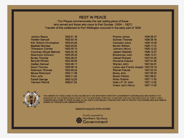
FORT DUNDAS MELVILLE ISLAND
NT Por 1644 Aboriginal Land Tiwi Lands Shire – located in the vicinity of the settlement – Geographical Co-ordinates 11 25 130 25 Fort Dundas was the military station established by the British on Melville Island 1824 to 1827
The plaque acknowledges those who died during the time of this Victorian settlement. This represented the first attempt to establish a British presence in the northern part of the continent.
Despite initial high hopes that it would become a permanent base, Fort Dundas was abandoned in the early part of 1828. For the duration of its brief existence, this small and isolated military outpost relied on convict workers both skilled and unskilled for the development and maintenance of basic infrastructure.
Captain Bremer was the first officer in charge of Fort Dundas on behalf of the Government of New South Wales, he was accompanied by soldiers and marines and some skilled workers who had answered advertisements placed in New South Wales newspapers. A few of the soldiers and marines were accompanied by family. Convicts could not be sent to Fort Dundas, they had to volunteer as the North was being managed by New South Wales on behalf of the British Parliament.
Terry Brookshaw from the UK has been able to supply additional information, missing from this plaque below is Richard Thomas, a Royal Marine, he died on 29 August 1825.
Royal Marine Courtney’s first name is Thomas, he was recruited in Dublin in 1813 aged 20.